Thursday, June 23, 2011

Euchre Bar, Alta, CA June 2011


This hike, while only about five miles total, qualifies as quite the challenge because 99% of the out is going downhill and 99% of the return trip is going uphill. It follows a series of steep switchbacks, well maintained loam and duff for the most part, down a hill side with about a 30 degree angle, down to the river.

To get to the hike, you'll drive along 80 Reno to Alta, and then drive along small roads, eventually ending on a well maintained single lane dirt road that leads you across two railway tracks ultimately taking you to the trail head. This dirt road can be driven on by just about any vehicle; we drove a minivan and saw a prius at the trailhead, for example, so no OHV necessary to access the trail. At the trailhead, be respectful of private property signs. The people that live out in this area, I think, must truly value their private space. :)

Once you see this sign (below):


. . . walk down the hill, and across the tiny creek (look for the 1950's car stuck in the tree near the creek):


Keep walking, looking for a small shady trail that leads you further down the hill. On that small trail, you should see, about 20 feet down the trail, this sign, nailed on a tree:


You'll also bump into this sign:


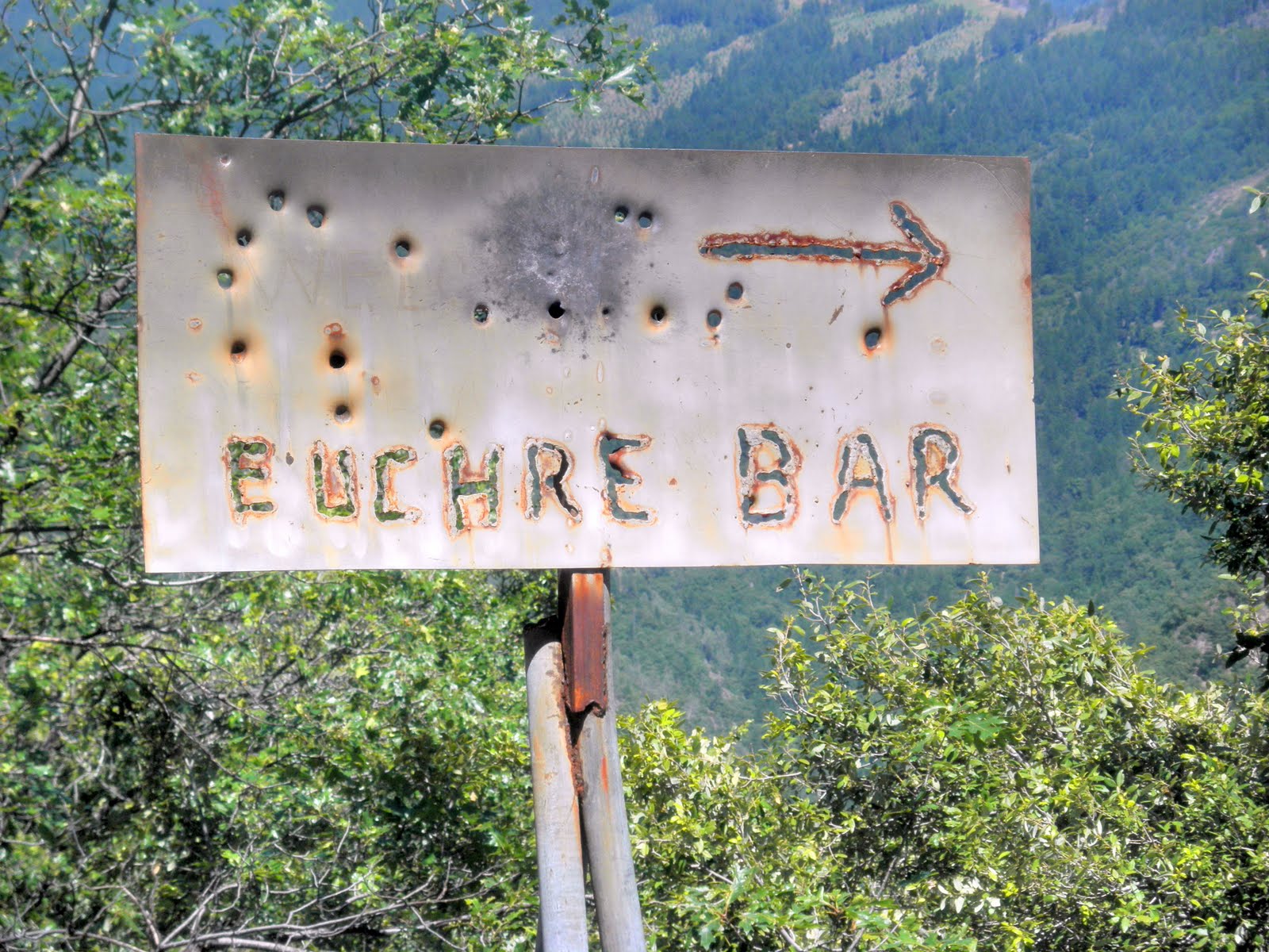
So--plenty of signs for the trail, which is helpful.

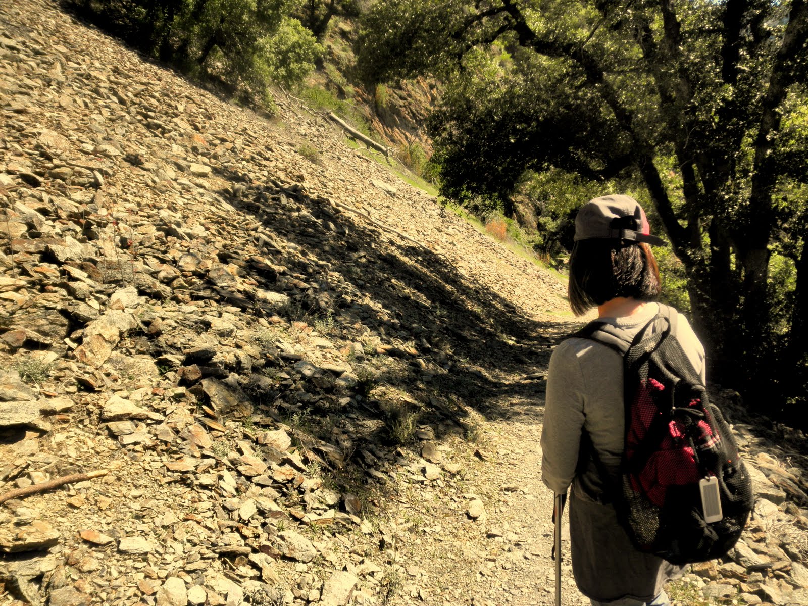
Below: a great view of the foothills, early in the hike:


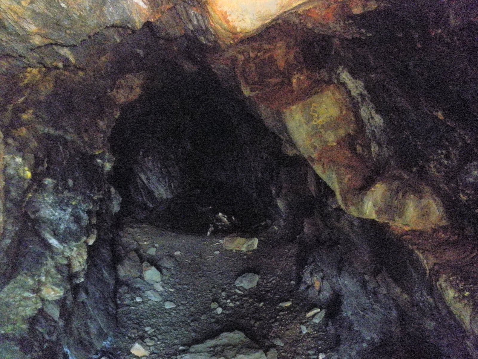
For the most part, the trail, while switchbacky, is in forest, so it's a good summer hike (or late spring hike). You'll still need a hat and block, but the forest brings a welcome respite from the more exposed trails possible in the foothills.

Closer to the river, we passed the foundations of an old mining cabin (?) along with rusted out bed springs and cans, which anywhere else we would likely have dismissed as junk. Here, on this trail, however, rightly or wrongly, we attributed the remnants to mining antiquities. :)


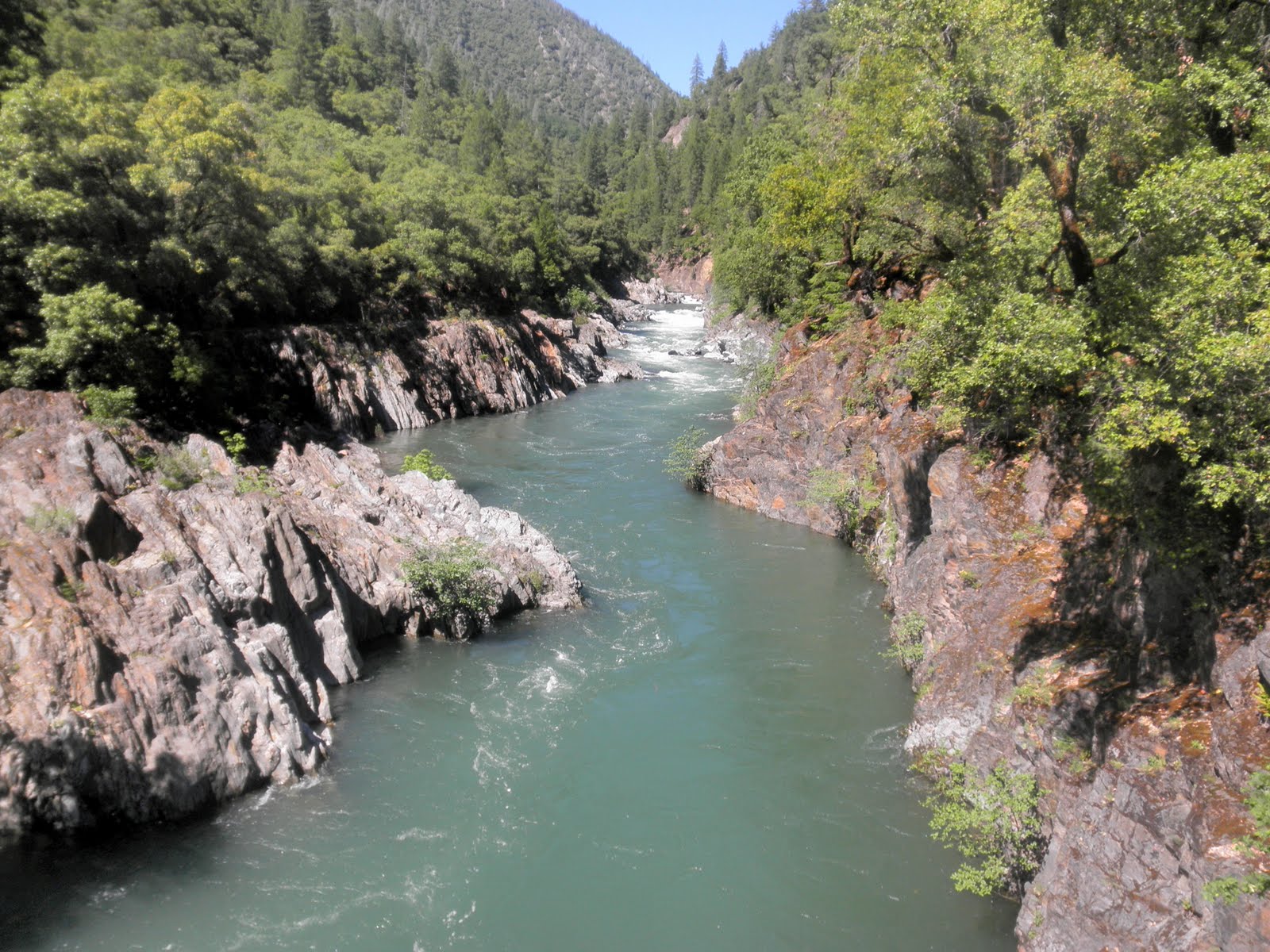
The destination is certainly beautiful once you get to the river, however, and if you continue the trail, you get to cross the only pedestrian suspension bridge over the North Fork of the American River, which is kind of cool . It was built in 1965, and it's covered with graffiti from the early 70's, which is kind of interesting--lots of Rolling Stones references, for example. :)


Interestingly and perhaps not too surprisingly, the bridge swings a little when you cross it, since it's suspension, and allows you great views of the river itself. With all the snow-melt recently, any trail with a view of foothill rivers is going to be stupendous at this time of year, so any river hike is going to be great, I think.


Below: a mid-bridge view of the North Fork of the American River. Just up this view, a young miner apparently fell to his death; there's a memorial plaque later in the trail that tells you a little more about him.


As we explored the bridge, we noticed also old mining paraphernalia--big nails and a giant metal cable holder, possibly to build the bridge or possibly because this area was a big mining area in its past.

Once my kids had tested Gallileo's theory of big rocks falling at the same speed as little rocks by throwing rocks off the bridge, we kept walking up the hill to follow the left fork. This path was a narrow and perilous trail that ultimately leading us to a wooden sign nailed on a tree on the bank, memorializing "Jeffrey Allan Blondell--1956-1980--A good miner but a better friend." I don't know this young man's story, but I do like his memorial.


This part of the trail ends suddenly, but if you track back to the main trail, and continue up, you can backtrack to the main trail, and instead take the right fork all the way to Humbug Creek, finding more mining paraphernalia along the way. It was hot, however, and my two boys and small white dog were ready to return home, and we still had that long uphill switchback in front of us, so we had our lunch, and treked back up the hill for to the car.


This trail was definitely an interesting hike, but I think you can get a better reward for effort with the Pioneer Hike (that waterfall!) or the Stevens Trail North hike (the views!) if you're looking for a winner of a foothills trail. Still, Euchre Bar is worth the effort if you're interested in the mining history of the area, and the river, no matter how you access it, is spectacular this time of year with all the snow-melt. Just be ready for 1500 feet elevation change in 1.5 miles.

Trail stats:
Trailhead to Euchre Bar--1.5 miles (but might seem longer due to switchback angles down/up)
Distance from home--about 80 mins
Trail surface--duff, loam, a few rocks. No scrambling. Well maintained. Shadey for the most part, but bring a hat and block.
DEFINITELY bring mosquito repellant. Those critters were HUNGRY on our hike, and we each emerged with at least 12 bites or so on our arms.

Saturday, June 11, 2011

Pioneer Trail, Emigrant Gap

Above: the snow melt from this winter's huge snow fall is evident in this picture of the massive waterfall, two miles into the hike. Amazing to see, particularly at this time of year..

We had a great time up near Grouse Ridge and Nevada City today, hiking the Pioneer Trail, a trail my son had found near Lake Spaulding. Our hike was a family affair this time out--my two sons and our dog accompanied me on the hike, and it was a fun day.

The trail starts out at a smallish trailhead, just over South Yuba River Bridge. The trail sign is merely a sticker on a metal post, but the trailhead itself is evident, so you should have no problem identifying it as your destination.


Below:Lighten your daypack: don't bring your gold prospecting tools; this area's been claimed already.


The trailhead itself sits at the side of the South Yuba River, which is a river I now regard with new respect; the recent snow melt has resulted in a impressive flow of roiling water, careening along, and as soon as you emerge from your car, all you hear is a roar of the water on its way down the hill.


The trail itself is a pretty easy trail as far as things can go. The surface is well maintained, with few dramatic elevation gains, and it follows along the side of the river for most of the time. The entire trail is 25 miles long, but since we were having a family hike and not a forced march, we limited the mileage to five miles total, which took us past this disturbing sign:


We eventually figured out that the water 'discharge' would not come from above us at a random place or interval, but rather from this impressive waterfall, two miles into the hike:


The waterfall, while human controlled via a dam at the top, was very impressive, with thousands of gallons churning down the hill into the river. We had no idea it was there, so it was a huge surprise and it made for a perfect lunch spot for us all. We gazed in wonder at the aquatic power in front of us.

The scarey sign, therefore, seemed rather to be warning people to stay off the boulders at the river's edge (about 30 feet below us) rather than warning people to stay off the trail itself.

Below: The deluge of snow melt had overflowed the river banks, as you can see from the picture below. The trail, however, was about 30 feet above the banks, so as long as you stayed away from the edge, you were fine.


The trail was mostly a single track in good shape and with a variety of surfaces--mostly loam but also with frequent granite chips.


Here and there, the trail had metamorphosed into a stream bed, and, because of the wet winter and recent snows, the creeks crossing the trail required some rock hopping here and there, but nothing too hard. Hiking poles can help balance you in those river crossing situations.

We walked mainly through forest, but we regularly had spectacular views of the river, churning below us, and periodically, we'd find ourselves walking through a spectacular foot hill meadow, walking past a verdant pasture, surrounded by a circle of pines.


As I walked along with my family and our dog, I was astounded at how lucky I am to be able to do this. My two wonderful sons were having a great time, enjoying outside activity in a wondrous natural environment. We are all healthy enough to hike, and we all enjoy hiking as a way to spend the day. We have the resources to get ourselves there and to enjoy it all. We live close enough for day hikes in this wonderful resource to be possible. Finally, we were fortunate to have perfect hiking weather.

We truly are amazingly fortunate. Hope you get the chance to explore the trail too.

Trail stats:


  • Trail info: The Pioneer Trail, built in a series of volunteer efforts from the 1980's to the mid 1990's, is 25 miles long one way. There are several trailheads along the way, however. We joined at the Lang Crossing trailhead, of CA 20, on the Emigrant Gap exit on 80.


  • Driving: Easy--just up 80--Emigrant Gap/CA 20 exit (#161). Drive right on CA 20; look for Bowman Lakes Road. Trailhead is a few minutes past the Lake Spaulding sign. About 90 mins from home.


  • Trail: mixture of duff, dirt, loam, and granite stones/rocks.


  • Parking lot is small--can fit about 6 cars, but not that heavily used, so should be ok. No facilities.


  • Weather: beautiful--70s, sunshine, breezy. No snow at 5000 feet in early June, which surprised me considering we're in a record snow year.

  • Traffic on trail: very little. We passed one other person--a trailrunner and her two dogs. We saw two other hikers at the trailhead, but didn't see them again.

Want to learn more:


https://legacy.losrios.edu/owa/redir.aspx?C=1fb656c5673e4ef5a7f7b61531d770b3&URL=http%3a%2f%2fwww.goldcountrytrailscouncil.org%2fPioneer_Trail.pdf

Sunday, May 8, 2011

Stevens Trail South, Auburn State Recreation Area


Above: a view from the trail of the roiling North Fork of the American River, boisterous and quick flowing due to all the snow melt in the last few weeks.


Maria and I decided to return to the Auburn State Recreational Area for this hike because we wanted to explore Stevens Trail South, the trail they call the "forgotten side" of Stevens Trail, and what an adventure it turned out to be.


To get to the trail, you drive to Colfax, and use the Canyon Way exit, and then turn on Iowa Hill Road. This little road will lead you past the Mineral Bar Campground along the bridge you can see from Stevens Trail South.

Below: A view from the suspension bridge we saw from Stevens Bridge North on our last hike. This view is looking back up to the North Trail.


Once past the campground, you drive up a squirrelly little one lane windy road until you reach the Iowa Hill Store.

To the right of the store, you'll see, set back a little, the trail sign (above). It's an unassuming start to the trail, but it's well worth the trip.


Once we reached the store and the trailhead, we found plenty of parking (opposite the store), and we also found ourselves surrounded by several large and friendly dogs, with a pit bull appearing to be particularly excited to see us arrive. As we unpacked our gear, a young man from the store emerged and asked us if we'd like to bring the dog along with us on our hike.


We're unsure what to say to his offer because we don't know this dog at all. The dog is a pit bull but appears to be very friendly and extremely enthusiastic about the upcoming walk. As we wondering what to say, the man further notes that the dog will keep bears away, and since that seemed like a reasonable argument to us, off we all trundled down the trail, with the pit bull, named Shorty, leading the way.


The trail starts out right by the store, but travel about 200 yards, through the forest, and then you pop out onto a southwesterny type of trail, lined by colorful river rocks, and altogether a delightful surprise.

Below: Beginning of trail--a southwesterny type of trail--well maintained and clearly signed.


Below: You can see an exuberant Shorty, galloping toward me at the start of the trail. At this point, I was wondering what we had gotten ourselves into with our guide, but it turned out great. :)


The trail continues, well marked, but soon transforms into a shaded, foresty trail for almost the entire way with periodic glimpses down to the North Fork of the American River about 1500 feet below.

Below: View of North Fork of American River from trail:


Throughout the hike, Shorty was a wonder. He led us throughout the entire trail; he would bound ahead, check things out, and then come back to check on us. Very sweet and great company, and we felt safe with him.


Now--I don't know if you've seen bear scat before, but I hadn't before this trail. We saw a few impressive examples of bear poop on this trail, and all I can say is that that animal is HUGE with a hefty appetite. The poop looked fairly recent, and it was good to know that Shorty was ahead, disturbing bears away from the trail. We felt probably unreasonably safe with him, but it was a good feeling to have.

If you go on this trail, therefore, and you're offered the hiking services of Shorty, I highly recommend taking the store owners up on the offer.

Shorty's a great dog--big and friendly (although he looks like he could eat your arm off), and he wants nothing more than to keep you company and to lead the way. He didn't beg for food, he drank from the creeks and from the river, and he was a great guide. He even has his own business card. :)


Below: I don't know what Shorty was looking for in the trees, but he spent a lot of time peering up into the branches along the trail.


The trail belongs to the Bureau of Land Management, but it appears that economic cuts have prevented their visiting the trail recently because there were about six downed trees, over which we happily scrambled through, over, and under, along with some eroded trail. It's an adventurous hike, therefore, but a fun one.


Below: The trail is somewhere under this mix of tree branches.


Below: About half way along the trail, you climb a small hillock wit the help of a thoughtfully placed knotted rope. :)

Eventually, at about 3.7 miles of gradual but constant descent, the forested trail pops you out on the shores of the North Fork of the American River, and you realize that you can see hikers on the Stevens Trail North just on the opposite bank. That was a fun perspective to have because Maria and I had hiked that trail a few weeks ago, so we could see what they were seeing. I felt as if we had achieved a 360 view of the trail, having hiked both the North and the South side of the trail.


At this point too, on the river's side of the trail, we found some old thick braided iron cables that, we think, could have been part of the original bridge across the river, joining the two trails together. That was a fun historical discovery for us to find. It helped us realize the intricacies of Stevens' work in the area. He ran a toll trail, maintained it (I guess) and the bridge, and he earned enough money to sustain himself in a decent way of life and then retire successfully. I wonder if he employed the same Chinese workers who built the rock wall on the early part of the Stevens Trail North.


Below: Maria on riverbank; we went down the bank and scrambled over the rocks to find the perfect lunch place on some flat rocks on the bank. Shorty found some shortcuts around and over the rocks, and he was happy mucking around exploring as we munched on our trailmix and sandwiches.


After lunch, we retraced our trail, with Shorty leading the way, and we realized that the return trip is where we pay the piper--it's all up hill, but not that bad. Just be ready for it. It's easy to forget you're going downhill on the way out because the grade is pretty subtle on the descent.


Once we had returned to the store once more, we could see that Shorty became visibly relaxed, because his charges were at last safe, and we had the chance to chat with the store owners to learn more about our canine guide.


It turns out that Shorty has been hiking for a while but has only recently decided that he's going to accompany all the hikers on the trail, to ensure that they return safely to the store. He's such a sweet dog, and the store owners are great people.


Stevens Trail North Trail vs Stevens Trail South:

The North trail is much more heavily traveled than the South trail; it has a little easier access from the trailhead, and it is more recently maintained. It offers some phenomenal views of the river, and it has unimpeded views of the surrounding canyons and hills. The popularity of the trail, however, means you have to give up some of the feeling of isolation that sometimes you need, and the crowded trailhead can mean some creative parking solutions, I think.


Still, those North Trail unimpeded views will translate into some hot hikes once the summer comes, and so the South trail is well worth a visit. It's a shaded trail for most of it, so it's good in summer, and it's more isolated, so it's good that way too. The views are fewer between, but they're also phenomenal, and ultimately, you get to have a quiet, isolated lunch, across the river from the crowded trail, and feel special that way, because you really did take the trail less traveled, and that does make all the difference (with apologies to Robert Frost). :)


Trail Stats:

Length: 3/7 miles to the river; about 7.5 miles total. Allow extra time for working through the downed trees and bouldering on the rock bank.

Weather: predicted to be showery, but dry. Mid-60s and sunny for the past, so great hiking weather.

Trail: duff, loam, some rocky gravel trail about 200 yards in. Forested for the most part.

Animals: definitely bear territory. I wouldn't go alone unless you're like the Grizzly Man. Do accept the store offer of Shorty, who's no trouble at all and is great company.


Monday, April 4, 2011

Stevens Trail, Colfax CA April 2011 II


Above: Wonderful view through the flowers to the North Fork of the American River, from the Stevens Trail. (Thanks, Maria, for the pic!)


After a few weeks of colds, flu, and vertigo, Maria and I finally made it out the foothills today. We were originally going to walk the Euchre Bar trail, but we discovered it was still under 18 inches of snow/ Instead, we drove back down the hill for 30 mins, and happily settled on walking the famous Stevens Trail near Colfax--an old, popular, and well maintained trail which offers tremendous views of (and ultimately access to) the North Fork of the American River. It's a great trail, and only about 70 miles drive for us from Sacramento, which makes it even better. :)


The weather was perfect--mid-60's to low-70's, a little breeze when you needed it, and plenty of sunshine.


Above: Welcome to the Stevens Trail trailhead.

The trailhead is large and overtly signed, but note that the 60 Hikes within 60 Miles of Sacramento book has a small but important error in the location of said location; it's on Canyon WAY and not Canyon Court (FYI).


The parking lot can fit probably 20 or so cars, with plenty of overflow parking on the street. Pay attention to the parking signs if you use the overflow parking, however. You may only park on the north side, I think, and it would be a bummer to get a ticket after a great hike.


The trail used to be a toll footpath between 1871 and 1906, and it took walkers between Colfax and Iowa Hill. It's a rare type of trail because, although it takes hikers down 1200 feet to the river's edge, it doesn't use any switchbacks. Instead it uses "gentle engineering" which results in a modest slope for the entire trail. A great break for the knees. :)

Above:Here, I'm standing on the table rocks just before the (rather precipitous) waterfall on the Stevens Trail.

Trail type varies, but is mostly dirt and rocks, with some shale slopes mixed in. There are some shady parts, but it's exposed for the most part, so take some block. It's a well maintained, well signed, and well traveled trail. Slopes are about 6% average, with 40% max, but it's really a fairly moderate hike, overall, in terms of difficulty.

Below: here are some pics of the shale part of the trail. Just above this shale slope is a yellow brick wall, built by the Chinese laborers back in the early Gold Rush, to retain the railway track that runs (or used to run?) above the river.


Below: Along the way, you pass an old gold miner's cave. It seems to go back a long way, but it's likely dangerous to explore too far in.


Below: On the way down the trail, and it's mostly down on the way out, but it's a fairly subtle slope for the most part, you can see the river down below:


Below: And here again--a high view of the river, this time with some beautiful lupins--flowers are abundant at this time of year:


Below: this is the bottom of a largish waterfall, the falls larger than normal because of the recent rains. It's about 30 mins from the beginning of the trail, and you have to cross it to continue the hike.

See that small shiny (wet, slippery, treacherous) rock in the middle of the water? That's your stepping stone to the other side. You can also see on the right the rather precipitous fall down the hill and how there really isn't too much margin for error. Additionally, in the middle top of the pic, you can see the tricky sharp, pointy, wet landing rock. :)

It's not normally, I understand, this submerged, but since it can be, just take your time crossing.


Below: Once you survive the waterfall crossing, you walk down further along the trail, and you are rewarded with this view for a lunch time breather.


Below: with all the rains recently, even the small feeder creeks are running strongly, as they rush down to replenish the American River.


Trail Stats:


  • The trailhead sign notes that it's 4.5 miles each way--9 miles total


  • Dirt and rocks for trail surface. About 1200 feet elevation loss along the trail.


  • Well maintained and signed overall; one early fork where you needed to keep to the left and go over a small hill to find the trail.


  • About four hours, including lunch and pic pauses.


  • Popular trail--good for solo hikers.


  • About 70 mins past Sacramento-an easy drive.
Want to learn more?
Link to Auburn State Recreational Area