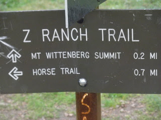
 I returned to Pt Reyes today to go retrieve my loyal hiking poles, waiting forlornly there in the Admin Building for their owner to pick them up. To commemorate their return to the fold, and since I had driven all that way to pick up the poles and since the weather was only light misting rain (for the most part), I went for a short celebratory hike up the Mount Wittenberg trail off Bear Trail. (I was on a time crunch, and I really only had about two hours there for a hike.)
It turns out, and perhaps not too surprisingly, that Mount Wittenberg trail is a relatively steep, in places, trail that leads to both other trails (Sky Trail and Coast Trail) and to the summit of Mount Wittenberg--really more of a large hill than a 'mount[ain].' No view of the ocean, but we had low clouds today, so perhaps on a clear day there might be a glimpse of the waves glinting.
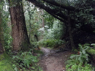
What was cool about this trail, however, is that it's an interesting mix of single track, loam, roots, and rocks, all the while surrounded by "Lost World" ferns, some dense, dark forest, a lush open meadow here and there.
Below: This tree is covered in a lace moss--which is actually, I think, a lichen and indicates the clarity of the air around that area; that lichen, if that's what it is, only grows in very clean air. Deep breath, everyone. :)
Throughout the hike, I had the inescapable feeling of being in a different world, and I would not have been surprised to have seen a raptor or some kind of dinosaur or, preferably, a hobbit. For the entire hike, I seemed to be the only person on earth, and this feeling of a solitary existence was quite a wonderful experience.


Below: I had no idea that these types of toadstools/mushrooms lived there (or, to be honest, were even real):


I would advise hikers to consider the summit of the hill a waypoint on the way to Arch Rock or elsewhere rather than a destination in itself. The summit did not seem to be that exciting a place in and of itself, as far as I could see, but the walk there. although relatively short, was great.
The Mount Wittenberg trail leads to a confluence of other useful trails which themselves can lead you to beaches, amazing views, and longer hikes, so the Mount Wittenberg trail is definitely worth integrating into a longer hike.
I drove through Point Reyes Station on my way home, and here's a picture of a famous sign there:

Weather:
- Overcast, light to moderate showers throughout (still grateful for my waterproof shoes and rain jacket; a baseball cap also keeps the rain off my face, which makes things more manageable for me at least)
- Low 50's (no gloves, yes, layers)
Stats:
- Bear Valley Visitor Center to Mount Wittenburg Trailhead: 0.5 mile
- Mount Wittenburg Trail to summit: 1.8 miles each way (3.6 miles total)
- Z Ranch Trail to 'summit' sign: 0.2 miles (barely)
- Time: about 1 hour 20 mins (with lots of looking, listening, and pausing for pictures).
- Drive-time: 2 hours from home
Next Point Reyes hike: Estero, I think and/or Arch Rock via Sky etc on a quiet day.
Want to learn more?
Point Reyes National Seaside site: http://www.nps.gov/pore/index.htm
Point Reyes National Seashore Association: http://www.ptreyes.org/index.shtml


