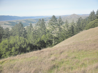
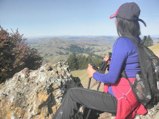
 Above: me enjoying the eastward view from the top of Barnabe Peak.
Last week, Maria and I went on a great hike to Barnabe Peak, a 1400 or so ft peak near Point Reyes, in the Samuel P Taylor Park. On the way, it was pretty foggy, but the fog has often cleared on the coast, so, on overcast days, it's worth driving from the valley to the coast for a clear hike.
Barnabe Peak is a great little hill on the coastal range, and it had been on my list for a while, so I was happy to hike there this beautiful weekend.
 Above: Devil's Gulch trail-head--the start of our Barnabe Peak hike and the way to access Bill's Trail--the trail up to our destination.
Bill's Trail is a very gentle trail which meanders through a large number of switchbacks; (some web hikers complain about the number of switchbacks, and there do seem to be an awful lot--easy on the knees, however, so pros and cons).
The trail, however, leads you though a damp, Hobbity-type of mossy forest, filled with water features and two waterfalls. One of the waterfalls, Stairstep Waterfalls, was flowing pretty well, and looked enchanting, sitting in the middle of the forest. The trail was pretty gentle, with plenty of switchbacks in the forest to soften any elevation gain. The forest was damp, mossy, and leafy, and a great place to be.
 Above: one of the several water features on Bill's Trail this past weekend. After a pretty wet winter so far, the waterfalls and creeks were active and flowing--it made for a fresh, damp experience in the woods and plenty of green.
 Above: a sampling of the well maintained Bill-Trail.
After about 3 miles of forest and shade (great for a summer hike), the forest trail eventually pops you out onto some welcome sunshine and great views.
 Above: the increasing light and thinning forest makes the end of Bill's Trail a ray of sunshine. :)
 Above: the view looking west as Bill's Trail leads to the Barnabe Peak trail.
 Above: The Barnabe Peak trail on the south side of San Geronimo Valley--14.7% grade, so fairly steep. Great to do in the cooler months; probably too exposed for summer, however.
 Above:: The Barnabe Peak trail, winding its up the hill toward the peak.
Above: We made it! Me enjoying the view from Barnabe Peak, looking east toward perhaps Mt Tam? Either way, a beautiful view and a perfect hiking day.
 Above:Maria, enjoying the north west view from the fire tower rocks at the top of Barnabe's Peak.
Up there also is a camouflaged cell phone tree; it looks pretty realistic. The fire tower is unmanned but well maintained. We heard an engine noise up there from something, but for the most part, the peak was quiet and preserved and a great view.

Above: One of our reptilian companions on Barnabe Peak.

Above: a sign to Bill's Trail as you come back down from the peak and look northwest. We took the trail to the left of this sign--Gravesite Trail, it turned out, and actually, closed as it turned out too. The sign did state that it was closed for ecological protection, but the map we had didn't clearly note that the trail we needed was Gravesite Trail. Oh well. I'm always happy with additional miles. :)

Above: The trail coming back down from Barnabe Peak, as we walk past Bill's Trailhead and look for the Gravesite Road trail.
We had some minor map confusion as we eventually realized that the trail we needed (Gravesite Trail) to get back to the car at Devil's Gulch was closed at this time of year to protect the plants. No worries; we just walked to the Madrone Group Picnic Area, and then crossed the road, walked back through the campground to the dump station and then onto the North Creek Trail, back to Devil's Gulch.

We could probably also have achieved basically the same goal by continuing, from Barnabe Peak, on the fire-road toward the southeast. It would likely have popped us out at about the same campground area. No problem; I'm happy to add miles to a hike, I'm not wild about hiking on fire-roads, and we still found the car but with a gentler grade going down.
Walking back through the campground to the North Creek Trail, we saw proof positive, if we needed any, that light travels in straight lines:

A great day overall, with great views and fun company. I'm happy to be back hiking again with strong knees and a spirit that longs for long views and continuing hikes. :)
Trail Stats:
Mileage: about 10 miles
Elevation gain: 1400 ft or so
Weather: clear, sunny, mid 60s--in January!
Trail: dirt, single-track, some fire-road up to the peak. Well maintained. Signed well but take a map anyway.
Want to learn more?
Here's another hiking blog review: http://www.redwoodhikes.com/Taylor/Barnabe.html
And one more: http://kevingong.com/Hiking/200206BarnabePeak.html.
Finally, here's the BAHiker page for the hike:http://bahiker.com/northbayhikes/sptbarnabe.html
No comments:
Post a Comment