Saturday, January 23, 2010

Point Reyes: Mount Wittenberg Trail

I returned to Pt Reyes today to go retrieve my loyal hiking poles, waiting forlornly there in the Admin Building for their owner to pick them up. To commemorate their return to the fold, and since I had driven all that way to pick up the poles and since the weather was only light misting rain (for the most part), I went for a short celebratory hike up the Mount Wittenberg trail off Bear Trail. (I was on a time crunch, and I really only had about two hours there for a hike.)

It turns out, and perhaps not too surprisingly, that Mount Wittenberg trail is a relatively steep, in places, trail that leads to both other trails (Sky Trail and Coast Trail) and to the summit of Mount Wittenberg--really more of a large hill than a 'mount[ain].' No view of the ocean, but we had low clouds today, so perhaps on a clear day there might be a glimpse of the waves glinting.

What was cool about this trail, however, is that it's an interesting mix of single track, loam, roots, and rocks, all the while surrounded by "Lost World" ferns, some dense, dark forest, a lush open meadow here and there.


Below: This tree is covered in a lace moss--which is actually, I think, a lichen and indicates the clarity of the air around that area; that lichen, if that's what it is, only grows in very clean air. Deep breath, everyone. :)


Throughout the hike, I had the inescapable feeling of being in a different world, and I would not have been surprised to have seen a raptor or some kind of dinosaur or, preferably, a hobbit. For the entire hike, I seemed to be the only person on earth, and this feeling of a solitary existence was quite a wonderful experience.


All the path, the ferns and forest were stunning; the surrounding plants were incredibly green and lush, just dripping with chloroform and fresh air and the appearance of growing before your eyes. The day was damp and cool, which lent the forest an even greater feeling of mystery. I felt that any time I would bump into one of the tule elk (which really do live there) or mystical creatures (which should live there).


One critter into which I did bump was a wonderful little lone woodpecker, actually pecking at a branch and making a slight knocking sound on the wood. It sounds like someone banging on a tree trunk with a pointy little hammer, which, of course, it really is, but I hadn't heard that sound before, and I found it enchanting. I've always wanted to see a woodpecker in action, so to speak, and now I have. I was really happy to spend a few minutes watching and listening to the woodpecker's work.

No woodpecker pics, however and unfortunately, because my camera only has a 7X optical zoom, and I needed a more sophisticated camera for this type of shot. Still, a wonderful memory for me from this hike.


Below: I had no idea that these types of toadstools/mushrooms lived there (or, to be honest, were even real):


Below: This tree has some interesting fungi growing on it:

The actual summit of Mount Wittenberg doesn't allow a sea view, but it is in a pretty meadow with lush forest surrounding it.
There's a sign noting "Mt Wittenberg Summit" about 10 yards off the trail near the top, but the sign is on a trail leading further up, so if that's the summit, the summit, interestingly enough, isn't actually the highest point on the hill. Hmm. I didn't have time to explore the trail past the summit sign, but it appears to go on further up for another mile or so.


I would advise hikers to consider the summit of the hill a waypoint on the way to Arch Rock or elsewhere rather than a destination in itself. The summit did not seem to be that exciting a place in and of itself, as far as I could see, but the walk there. although relatively short, was great.

The Mount Wittenberg trail leads to a confluence of other useful trails which themselves can lead you to beaches, amazing views, and longer hikes, so the Mount Wittenberg trail is definitely worth integrating into a longer hike.

I drove through Point Reyes Station on my way home, and here's a picture of a famous sign there:


Weather:
  • Overcast, light to moderate showers throughout (still grateful for my waterproof shoes and rain jacket; a baseball cap also keeps the rain off my face, which makes things more manageable for me at least)

  • Low 50's (no gloves, yes, layers)

Stats:

  • Bear Valley Visitor Center to Mount Wittenburg Trailhead: 0.5 mile

  • Mount Wittenburg Trail to summit: 1.8 miles each way (3.6 miles total)
  • Z Ranch Trail to 'summit' sign: 0.2 miles (barely)

  • Time: about 1 hour 20 mins (with lots of looking, listening, and pausing for pictures).

  • Drive-time: 2 hours from home
Overall: A nice little trail--lush, solitary, and beautiful. Well worth considering doing in order to avoid the inevitable crowds on Bear Valley Trail to Arch Rock.

Next Point Reyes hike: Estero, I think and/or Arch Rock via Sky etc on a quiet day.

Want to learn more?


Point Reyes National Seaside site: http://www.nps.gov/pore/index.htm


Point Reyes National Seashore Association: http://www.ptreyes.org/index.shtml

Sunday, January 17, 2010

Non-Sequitur


Found this funny commentary about how self-righteous we hikers can get with non-hikers: :)

"As mentioned earlier, [hikers] love to be outside. But not everyone knows that another thing they like to do is make people feel bad for wanting to watch sports on TV or play videogames. While it would be easy to get angry at [hikers] for this, remember it is hard wired in their head that the greatest thing a person can do in their free time is to hike/walk/bike outdoors.

Usually, they will see that you are preparing to enjoy your life and they will say “hey, lets go for a hike in the park,” and most people will say “hey, thanks but I’ve been working all week and I’m really excited about watching this game,” and then they will respond “don’t be a lump on the couch, you’re wasting your life away, etc…” If you ignore them, they will eventually go away.

And much like most things with [some] people – they win both ways. If you decide to go with them, they feel good about getting someone off the couch and “into the fresh air,” and if you don’t decide to go, they can spend their entire time outdoors saying “boy, this is great, X doesn’t know what he/she is missing!” and running on a mix of self-satisfaction, Odwalla juice and muesli
."

It's originally from Stuff White People Like, but it really could applyto hikers in general--myself included. :)

Saturday, January 16, 2010

Point Reyes Nat'l Seashore: Bear Valley to Arch Rock


First, after I had healed just fine from the appendix, I injured my knee after some ill-advised running, and so I couldn't hike from just before Christmas until today.

But--today finally came, and I judged my knee was strong enough to handle a hike. This time, we went off, this time not up the Hill, but rather to the Point Reyes National Seashore to explore the hiking gems there.


My intrepid friend Maria and I decided to hike from Bear Valley Visitor Center along the:
  1. Bear Valley Trail to
  2. Arch Rock whereupon we had lunch and then returned via
  3. Sky Trail to
  4. Coast Trail to
  5. Baldy Trail which led us safely back to the last part of
  6. Bear Valley Trail and the Visitor Center.
All the trails are well signed, and the Visitor Center has trail maps and lots of advice. I left my loyal hiking poles there, incidentally. Sigh. I called the center, and the ranger said they'll hold them safely until I return on Friday to pick them up.

After several weeks of foggy weather, it was a relief, once we arrived on the coast, to see that the weather cleared for the first half of the hike for a very much appreciated clearish day, clear enough for sun-block and a cap.


The weather was also easily clear enough to enjoy the views at Arch Rock.

Below: views of the coast looking North (top) and South (bottom) from Arch Rock


On the rock, we found ourselves in a gaggle of Boy Scouts, also out to enjoy the day, and coincidentally, the Meetup group. :)


Bear Valley Trail: highly popular trail because it's the most accessible trail from the Visitor Center. Be prepared for company (trail runners, families, Boy Scouts, mountain bikers). It's very workable to share the trail, but just don't go expecting isolation.

The trail itself is a smooth, fire trail really, but with loam. Pretty muddy, of course, this time of year, but as Maria noted, there's really 'no bad weather; only bad clothing.' We were well prepared with waterproof boots and layers, so the mud and weather was no issue to us.

Some mountain bikers here and there on the trail; they can bike up to the four way junction of Glen Camp, Bear Valley Trail (which continues straight) and Baldy, but there they have to lock their bikes to a bike stand and then hoof it the rest of the way.

Bear Valley Trail leads all the way to Arch Rock, a largish, smallish promontory, jutting out into the sea--great for lunch and rugged Northern CA coastal views.


Whales are a little further up north by the Lighthouse, so no whales for us today, but,during our lunch break, we did see plenty of diving seagulls and what looked like cormorants, plunging into the sea. All of the wildlife action was accompanied, of course, by stunning ocean views.

The actual arch is underneath the promontory, so if you want to see it, you have to climb down a steep little use trail just before you get to the rock outlook, and then clambor over a tide pool or two. It's worth doing, but you need steady feet on the way down and on the slippery rocks. If you do go down, be careful also as you stand looking at the archway. Rogue waves come up through the arch, and they can at least splash you if not threaten to knock you down/into the sea.

Below: We joined the scouts who had earlier clambored down the trail because we all wanted to see the famed 'arch' of Arch Rock.


The gentleman in the white hat in the picture above got soaked a few seconds after this picture was taken. Fortunately, however, neither the guy nor any of the scouts was knocked into the sea. I was amazed and relieved that nobody needed rescuing.
My son later advised me to "Never stand on wet rocks." Wise advice, my friend, wise advice.

Coast Trail to Sky Trail: the Coast Trail leads pretty quickly to the Sky Trail, abd both are off the beaten path compared to Bear Valley Trail. Coast and Sky are each much smaller trails than Bear Valley (which appears to be one of the main trails from the Visitor Center--much more accessible than these smaller trails).


Sky Trail is a single track trail, pretty steep in places, which takes you up through ferns and trees. It's a pretty trail, with periodic views of the ocean here and there. Because it's steeper, there are many fewer people on it, so it's a much quieter way back than Bear Valley Trail.

Below: views of Arch Rock from near Sky Trail. Looking below at the ocean line, you can kind of see the North side of the arch.


Baldy Trail: No pics for this one, but Baldy is also a much quieter trail than BV Trail because it too is steeper (only going down this time) and because it's a single track. Very foresty and ferny, very pretty, and accompanied by the chuckling of a creek with periodic tiny waterfalls.

Weather:

  • Mostly cloudly for the first half, with increasing mist leading to a pretty steady shower for the second half. It's a good idea to bring water/windproof layers to the coast, even in summer.

  • Temps were mid-high 50s, so not cold.

  • Always windy on the coast, however, so bring some layers for the time spent on Arch Rock.


Stats:

  • Bear Valley Trail to Glen Camp/Baldy junction: 2.9 miles

  • Bear Valley Trail from junction to Arch Rock: 1.0 mile

  • Coast Trail to Sky Trail to Baldy Trail: 1.5 miles

  • Baldy Trail to Bear Valley Trail junction: 1.1 miles

  • Bear Valley Trail back to Center: 2.9 miles

  • Total mileage: 9.4 (plus about half a mile of wandering around exploring).
Time: about five hours (including pauses on trail for pix and lunch on rock).


Point Reyes National Seashore website: http://www.nps.gov/pore/index.htm

Overall: highly recommended--great trail. If you'd like a quieter route to Arch Rock, avoid Bear Valley Trail.


Saturday, December 5, 2009

Brief Hiking Hiatus


Mod ab pain starts: Mon 11/16; continues all the way all day steadily, so . . .

Dr apptmt: Tues 11/17; advises me to go immediately to the . . .


. . . where I have a CT/Labs/Admit: Tues 11/17 pm. All evidence points to the need for an . . .


Lappy Appy Surgery: Wed 11/18 11am

D/C: Fri 11/20 1pm--great docs and nurses in a great hospital. Cool.


Back to full workout w/ situps and good cardio: Tues 11/24

Predict back to hiking: 12/05-12/12 depending on weather.

Can't wait.

Sunday, November 15, 2009

Summit Lake, Tahoe, Nov 14 09


Pic above: Very Narnia, wouldn't you say? This is a pic of early in the hike, going along the Castle Pass PCT Trail. Stunningly beautiful, I thought, and quiet, quiet, quiet. Just the crunch of my boots and the rustle of my pack.

Weather: a stunning "blue bird" day, as the snowboarders say: sunny, low 40s, no wind, no clouds, just plain ol' gorgeous. A great day to explore winter hiking with new gear.

Stats: The Top Trails book suggests starting this hike at the Boreal PCT trailhead, but that trailhead charges you snow-park parking rates after Nov 1, so I parked instead across 80 (well, under 80) at the Castle Valley Road trailhead. It added about 2 miles to the hike, but I wanted to do a longer hike anyway.

There's an I-80 rest-stop on the Castle Peak side of 80 just before you get to Boreal exit. There's no unattended cars allowed at that stop, however. Instead go to the PCT trailhead (if before Nov 1) by Boreal, and park there instead. The PCT start makes the hike a little over four miles.

If it's past Nov 1, then just drive under the freeway at the Boreal exit, and then park along the side of the Castle Valley Road; then you can walk up the (dirt) road a mile or so to the junction with the Donner Lake Rim Trail (off to the right through a meadow). The Castle Valley start made it 6.5 miles--perfect. 3 hours with only a few photo stops and one or two changes in trail plans along the way.

Gear: Since it was my first real winter hike, I was anxious to see how the gear would perform: Keen Waterproof Targhee II Cross-Trainer shoes, OR low gaitors (with red straps), REI Mistral pants (waterresistant, windproof, softshell), base layers, synthetic t-shirt, light fleece, REI Mistral soft-shell, SmartWool beanie, Swix gloves, handwarmers.


Poles were really helpful on this hike in particular; they helped me decide which piles of snow were just snow or instable rock or stable rock--all of which were helpful pieces of info when crossing small streams and rockbeds along the way.

I started out the hike in all the gear but, as I warmed up, spent most of the day in just the fleece and base layers on top; all of the gear worked splendidly, and I learned that, with the right gear, a sunny snow day-hike can be really great.

My feet were warm and dry in the Keen shoes, with no hotspots whatsoever, and the gaitors worked out very well keeping the snow away from the tops of my shoes. I only have low gaitors, and I was in 4-5 inch snow; the knee high gaitors, I think, could be overkill for most day-hikes; perhaps they're for mountaineers. Of course, I didn't explore Castle Peak with snow, so who knows?

Handwarmers and good winter gloves made my hands and fingers sing for the first half of the hike (when I no longer needed gloves); chemical hand-warmers last about seven hours and weigh next to nothing; they're well worth bringing along.

Pants were very comfortable (wind proof, water resistant, soft shell with fleece lining) although I realized that I need a belt to keep them exactly in place as the hike progresses.

Below: the view from early in the hike on the Castle Pass PCT trail: while tiny parts of the hike was on wet trail, most of the hike had snow around 4-5 inches, a mix of icey crunch and powder--delightful and a great workout.


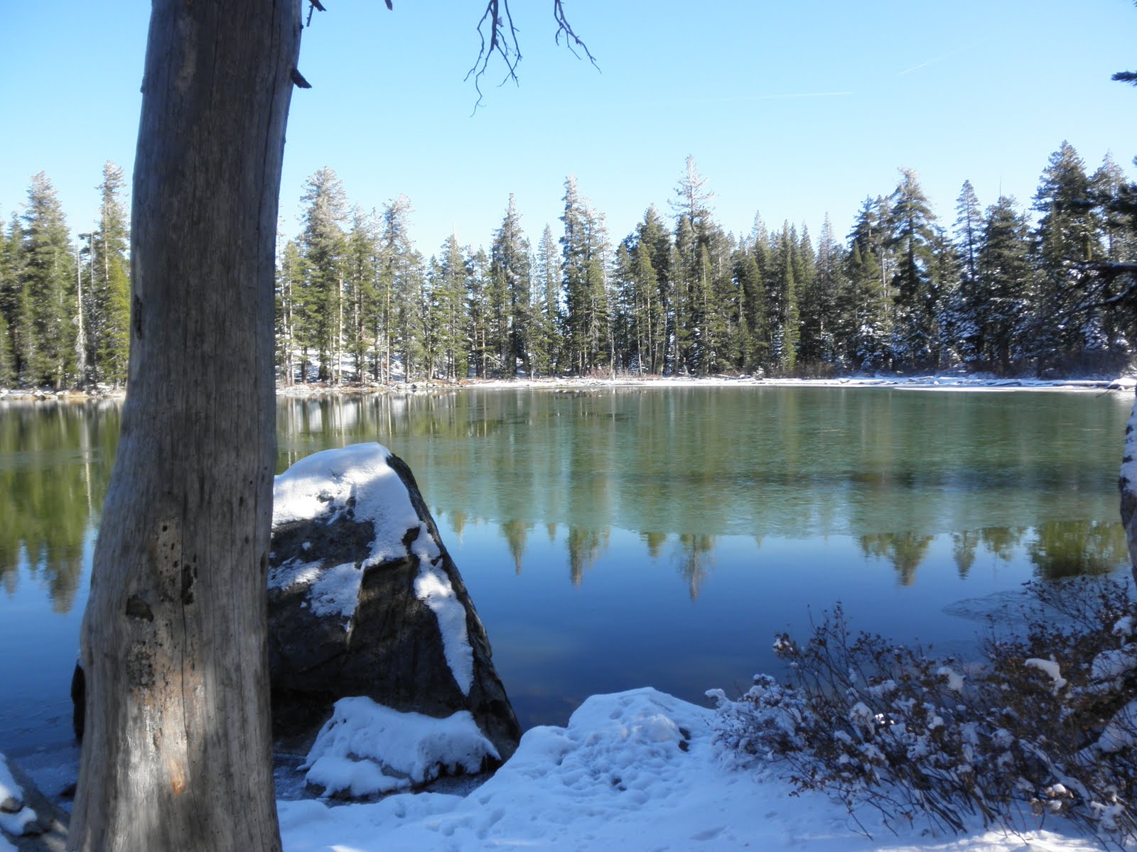
Below: pix of Summit Lake--summit to see, indeed. Not another soul in sight, no critters to be seen or heard, just me and the lake and the sun. Wonderful. It's not that high a lake by Tahoe standards, and it's not a huge one either, yet it's still worth the hike.


Below: The hike is quite well-signed, with periodic small Donner Lake Rim Trail signs affixed to trees as a comforting touch. I always take with me, though, a xerox of the map from Top Trails, just in case the posted signs don't mesh with my expectations.


On the way back to Castle Valley from the lake, there's a three way junction about 2 miles from Summit Lake; at that three way junction (one to the I-80 rest-stop, one back to Summit Lake, and one to Castle Pass), take the Castle Pass trail to get back to your car on Castle Valley Road.

I learned also that on snow-covered trails, it's good

a) not to be the first person on the trail since the snow fell and

b) you have to believe that the footprints into which you're treading (cue King Wencelas from the carol) are going to your destination. It pays to pay attention to surroundings, of course, to ensure that the footprints are heading at least in a feasible direction. You don't want to follow a crayzee off trail person, after all.

Ponderings about the hike:
It wasn't deep enough for snow-shoes although I can see how snow-shoes will be fun. That's definitely for my to-do list--try snowshoeing this year.
The trail is as close to Boreal as you can be and not be at Boreal. Very convenient if you have skiers/boarders in the family but you don't ski or board. No snowshoe or X-country at Boreal, but there is some X-C at Royal Gorge which is only a mile or so away from Boreal. Hiking always available at Castle Pass, however.
I can see how crampons (or some kind of additional grip sole for boots) could come in handy going up a steep hill--Castle Peak, say, or Ralston.

It's fun to look at animal tracks in the snow; I saw several coyote print trails and lots of smaller animal trails along the way. Cool.

Next Boreal day-hike is Peter Grubb hut.

More info about Summit Lake: http://gorp.away.com/gorp/resource/us_national_forest/ca/tahoe_trails/summitla.htm

Friday, November 13, 2009

Finally, the hiking shoes I love

After much gnashing of teeth (and toes and heels), I have finally settled on my hiking footgear--Keen Targhee II hiking shoes.


I wore them for today's hike up to Blue Ridge, with no problems at all.

No toe bashing? Check.

No heel rubbing/hot spots? Check.

No hot spots with laces? Check (once I'd reconfigured laces like the local running store showed me).

Good for plantar fasciitis? Check--no problems, very supportive.

Waterproof? Check.

Comfy? Check.

Cool (in all meanings of the word)? Check.

Happy hiker?

Check.

Stebbins Canyon/Cold Canyon Hike, Nov 13 09


Hike: 5.0 mile loop around Stebbins/Cold Canyon, via the Homestead Trail to Blue Ridge and then back down to the lot. Steep, clambory (more than expected), but fun.

Weather: perfect hiking weather for the valley--cool, bright, clear, no wind. Perhaps mid-50s/low 60s.

Stats: 30 mins from home; hike is 5 miles long--about 2.5 hours to complete with a few photo stops.

The hike starts off at a moderate grade following the (currently dry) stream bed in the canyon. No rattlers today, which was nice; they must be hibernating (or thinking about it) by now. Lots of interesting rocks on the trail, which eventually led us to the abandoned homestead at about 1.0 miles.

We continued further up the trail; take the steps off to the right, opposite the first homestead ruins you see to find the Blue Ridge trail. This trail is pretty steep in places, with 'elevation assists' (otherwise known as stairs--over 200 of them, I've heard) and plenty of switchbacks.


Periodically, the trail appears to disappear, but just look carefully, even up over rocks, to find it continuing its ascent towards the Blue Ridge peak.

Bring your climbing shoes--hiking boots with good grip a must for the rock clamboring necessary to reach the peak from the Homestead side. Poles are helpful too.

Below: the views of the surrounding hills are stunning; hard to believe I haven't been here yet lived in the area so long.


Below: A view of Lake Berryessa from the Blue Ridge peak:


Below: A sampling of the trails: hard packed dirt mixed with large boulder size clamboring rocks: pretty interesting, quite technical in places.


Overall: a fun, local, easily accessible trail day. I was pleased to be able to explore finally the upper echelons of the Cold Canyon area. It's well worth exploring again.

Learn more about the trail: http://www.berryessatrails.org/guide/trailguide/coldcan.htm
(UC says the trail is five miles; the berryessa trails site says four. You choose.)